
INTEGRATED MANAGEMENT OF LAND BASED ACTIVITIES
IN THE SĂO FRANCISCO RIVER BASIN PROJECT
ANA/GEF/UNEP/OAS
Activity 1.2 - Environmental Assessment of Mining Activities in the Water
Resources of the Upper Rio das Velhas
Executive Summary of the Final Report
ENVIRONMENTAL ASSESSMENT OF MINING
ACTIVITIES IN THE WATER RESOURCES OF THE UPPER
RIO DAS VELHAS
Instituto Mineiro de Gestăo das Águas
Belo Horizonte - MG
INTEGRATED MANAGEMENT OF LAND BASED ACTIVITIES
IN THE SĂO FRANCISCO RIVER BASIN PROJECT
ANA/GEF/UNEP/OAS
Activity 1.2 - Environmental Assessment of Mining Activities in the Water
Resources of the Upper Rio das Velhas
Executive Summary of the Final Report
ENVIRONMENTAL ASSESSMENT OF MINING
ACTIVITIES IN THE WATER RESOURCES OF THE UPPER
RIO DAS VELHAS
Coordination
IGAM - Instituto Mineiro das Águas
Director
Willer Hudson Pós
Coordinator
Victória Tuyama Sollero
Contract CPR PO nş 10430
Editor
Golder Associates Brasil Ltda
Belo Horizonte - MG
November 2001
ENVIRONMENTAL ASSESSMENT OF MINING ACTIVITIES IN THE
WATER RESOURCES OF THE UPPER RIO DAS VELHAS
EXECUTIVE SUMMARY
INTRODUCTION
When preparing the "Integrated Management of Land Based Activities in the Săo Francisco
River Basin Project - GEF/ANA/OAS/UNEP, the GEF Săo Francisco Project, one of the main
environmental problems in the upper reaches of the river was found to be the impact of mining
activities on the water resources of the Rio das Velhas.
Activity 1.2 ("Environmental Assessment of Mining Activities in the Water Resources of the
Alto Rio das Velhas"), part of the Environmental Assessment component of the GEF Projects,
was undertaken with donation funds provided by the Global Environmental Facility GEF and
was implemented by the United Nations Programme for the Environment UNEP. The
international executive agency was the General Secretariat of the Organization of American
States OAS. Initially, the national executive agency was the Water Resource Secretariat of the
Ministry of the Environment SRH / MMA, but the responsibility was transferred to the
National Water Agency ANA, in May 2001.
The Minas Gerais Water Management Institute - IGAM, a governmental entity linked to the
Environmental Secretariat of the State of Minas Gerais, was in charge of the coordination of the
Activity, at the local level.
1. MINING AND WATER RESOURCES AT THE UPPER RIO DAS VELHAS
Considering the concentration of mining at the upper reaches of the Rio das Velhas, for centuries,
a 2,000 km˛ area was marked for the study. Coincidentally, the area is inserted in the geological
context of one of Brazil's major mining provinces, known all over the world as the Iron
Quadrilateral of the State of Minas Gerais, where a great variety of minerals are exploited,
especially iron ore, gold and gems.
Iron ore mining, followed by gold and gems, is undoubtedly the most important mining product
of the Region, both for its economic significance and associated infrastructure, and for the
magnitude of its pits and waste and tailings deposits. The extraordinary movement of 56 millions
of tons a year of mined iron ore expresses this dimension, as do the 55 millions of tons of waste
material annually removed and disposed of in heaps alongside the excavations and 17 millions
tons deposited in tailings dams or ponds. As a result of the removal of waste and the exploitation
of ore, voids are formed at a rate greater than 40,000 mł/year. The deepening of these pits nearly
always usually requires lowering the water level in practically all the larger pits, at a continuous
discharge of 0.480 mł/s.
The iron ore deposits are inserted in geological formations with the greatest potential for water
resources investigations. These formations, as well as other with diversified groundwater
potential, comprise large synclinal geological structure systems, forming large underground
reservoirs, known as the Moeda and Dom Bosco aquifer systems, associated to the synclinals of
the same name.
i
These two large aquifer systems are, certainly, responsible for the greater share of water supply to
the springs in the Upper Rio das Velhas Basin. The impoundments of the Rio das Velhas and
Morro Redondo Systems, with discharges of 5.2 and 0.6 mł/s, respectively, supply nearly 50% of
the requirements of the Metropolitan Region of Belo Horizonte, Capital of the State of Minas
Gerais, with a population of about 2,000,000 inhabitants and part of its industrial sector.
2. ANTECEDENTS IN WATER USAGE CONFLICTS
Water supply demands of the City of Belo Horizonte, the growth of intensive mining activities in
the region, growing urban occupation, the rise in the expansion of high class residential
condominiums and leisure homes, encouraged by the exuberant beauty of the area, with mountain
scenery of spectacular beauty, has lead to an apparent incompatibility of uses, resulting in
irreconcilable conflicts of interest, certainly with great impact on the social and economic issues
in the area.
These conflicts will most certainly be magnified greater among the distinct segments of society
directly or indirectly involved, during the already started debates for preparation of the economic
and ecological zoning of the Environmental Protection Area South of Belo Horizonte. This zone
is being created by the State Government, in response to pressure of the local community,
viewing the protection and preservation of the existing natural resources.
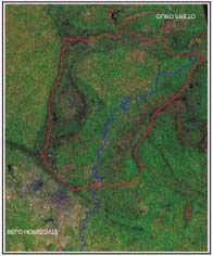
Figure 1. Location of the Rio das Velhas Basin
Considering these antecedents, the Upper Rio das Velhas Region, shown in Figure 1, was chosen
as a study case for the Săo Francisco Project, for the development and application of the specific
methods used in the assessment of impacts, applicable to other basins with similar features,
ii
fulfilling GEF's objectives. It also aims at the identification of new actions and environmental
projects, in local or regional scopes, which may be considered in the Integrate Management
Program, main objective of the Săo Francisco Project.
3. ACHIEVED DEVELOPMENT AND RESULTS
In agreement with GEF, UNEP, OAS, ANA and IGAM, the name of Activity 1.2 was changed to
"Environmental Assessment of Mining Activities in the Water Resources of The Upper Rio das
Velhas", in place of "The Impact of Mining on the Water Resources of the Rio das Velhas".
The studies included a multi-disciplinary environmental assessment of the selected area, which
can contribute a great deal to the control and inspection procedures of the mining activities, by
local control entities, with regard to the commitment to the impacted water resources. In order to
achieve the established objectives, an attempt was made to identify and evaluate the mining
environmental impacts on the quantity and quality of surface and underground waters. Based on a
diagnostic analysis of the progressive commitment to these waters, an Environmental Action Plan
was to be proposed, viewing the re-establishment the natural conditions of the waters, essential
for meeting local needs and for the entire Basin, as part of the Integrated Management Program.
Activities included an Environmental Perception study, which attempted to find and evaluate the
points of view of the formal and informal representatives of the communities directly involved
with the issue. Work began in January of 2000, following the five stages illustrated in Figure 2.
Besides the products resulting from the above stages, presentations of the Activity's progresses
were made to different groups of interest, with distribution of graphic material prepared
especially for the turning public the Project. The events were attended by representatives of the
several segments of local society, directly or indirectly involved with the subject.
An exceptionally interesting occurrence took place during the seminar, permitting a precocious
evaluation of the importance, scope, suitability and opportunities offered by Activity 1.2, to the
Upper Rio das Velhas Region. On the 5th of May of 2001, when the workshops were in progress,
presenting the main outcomes, a tailings dam of a medium size mining company (Mineraçăo Rio
Verde) burst, with very serious consequences, causing five deaths and great devastation over
three or four kilometers of the riverbanks of the Taquaras Stream. The damages occurred in an
area of well preserved luxuriant vegetation, a region known as Macacos, in Săo Sebastiăo de
Águas Claras, District of Nova Lima, and included the bursting of main pipelines in the
impoundment station of Fechos, of the Morro Redondo Water System (COPASA) and breaking a
bridge on a secondary road.
This accident, with serious social and environmental consequences, brought immediate interest in
the Activity's outcomes being presented at the seminar, as this was, at that time, the only study
with regional scope focusing both on quality and quantity, in the assessment of impacts OF
mining on the water resources in the Upper Rio das Velhas. Therefore, after a period of
questioning and evaluations by many representatives of the involved technical agencies, the
outcomes of the Activity have been used as basis for a new model of controls of impacts of
mining activities on water resources, not only for the study area but also for the entire State of
Minas Gerais.
iii
1.
2.
3.
4.
5.
Figure 2. Work stages and basic associated activities
It is evident that the methodology developed for evaluating environmental impacts of mining on
water resources, with the proper adjustments, can be used not only in the Săo Francisco Basin but
also in similar environments, in many parts of the World.
Recommendations were also made for actions and projects designed to preserve and manage the
water resources, applicable to the neighborhood, represented by the Upper Paraopeba River Basin
and the remaining Săo Francisco River Basin. Estimated planning and implementation costs, for
these, are almost US$ 5,000,000.
4. THE GEOREFERENCED INFORMATION SYSTEM
The multi-disciplinary aspect of this study required collecting and managing a great deal of data,
in order to allow an integrated assessment of the involved issues. Data processing and
management was done with the implementation of a Georeferenced Information System (GIS),
especially designed for this work, based on a relational databank structure and on a system of
geographic information.
Studies were based on secondary, official and public data, made available in time by the several
consulted sources. The thematic approach for preparing the integrated diagnosis considered a
regional scale of 1:100,000, over cartographic charts on 1:50,000 scale.
The GIS structure was based on the classification of categories of compiled data, either
cartographic or alphanumerical. Consolidating the structure required several stages for refinement
and adjustments, in order to assure better levels of information for subsequent stages.
iv
The Cartographic Databank was formed from information stored and managed by ArcInfo and
ArcView software. More than 100 layers of geographic and registered information were created,
allowing the preparation of several thematic and diagnostic maps.
The Alphanumerical Databank, created for managing greats amounts of data related specifically
to aspects of water availability/quality and mining activities, in MS-ACCESS format, allowing
the use of its efficient search features by members of the team, during assessment or evaluation
procedures, and by future users.
5. INTEGRATED ENVIRONMENTAL DIAGNOSIS
Preparing an Integrated Diagnosis for the area in question began as a pre-identification of the
thematic study blocks and their respective variables, capable of including all aspects considered
relevant for the evaluation of mining impacts on water resources.
The method applied for integrating the thematic approaches permitted knowing and quantifying,
in the existing scenario, the most relevant environmental impacts resulting not only from mining
activities but also from other anthropic uses in the region, as shown in Figure 3. The main aspects
considered in the thematic analysis and corresponding results are presented below.
Figure 3. Evaluation of impacts and diagnosis
5.1 SURFACE AND GROUNDWATER AVAILABILITY
For evaluating water resources availability, a databank of basic information, with geological,
hydrogeological, hydrometric, sedimentary and climatic data, was created, including studies and
projects made by other institutions, for the area.
The evaluation of groundwater resources was conducted in a manner as to allow an estimate of
the effective water availability, by hydrostratigraphic units, based on discharges from deep
tubular wells and natural flow from these to the drainage network in the Basin. As shown in
v
figure 4, the identification of the aquifer systems was based on the correlation of the basic
regional lithostratigraphic column with its hydrogeological characteristics. It should be
emphasized that the main hydrostratigraphic units host the iron reserves of the Cauę Formation,
where the iron ore mining companies operate. Those companies are the main cause of impacts,
due to excavations and aquifer lowering, required for deepening the mines.
The evaluation of surface water resources was done through quantification of the hydrological
regime of main streams, summarized by the average and minimum flow characteristics obtained
from a regional study. Estimates were made using historic series from 8 pluviometric and 9
fluviometric stations in the area, with different durations, varying from 25 to 62 years. A
summary of the groundwater and surface water potentials, by hydrostratigraphic unit, is seen in
Figure 4.
Figure 4. Effective water availability
Results allow us to conclude that the left bank tributaries of the Rio das Velhas show greater
contribution to minimum discharges during the dry season than the right bank ones. They
contribute with approximately 70% of these discharges, estimated at a little more than 7 mł/s.
Undoubtedly, the greatest water demand corresponds to uses outside the river basin, to the City of
Belo Horizonte, which requires 5.8 mł/s from the Rio das Velhas and Morro Redondo Systems.
Within the Basin, even though well inferior to the water rights granted to the Bela Fama
impoundment, two uses are emphasized: the mining industry (with a consumption of 0.62 mł/s)
and urban supply for the towns in the Upper Velhas Region (Itabirito, Nova Lima, Rio Acima,
Raposos and Ouro Preto), equivalent to 0.149 mł/s.
vi
5.2 WATER USE IN THE PRODUCTIVE SYSTEMS AND MINING OPERATIONS
A diagnosis of the current mining operation conditions was made based on registers in the GIS
prepared for this work. All relevant quantitative and qualitative information were processed and
evaluated, aiming at a better understanding of the actual impacts that mining operations might
have on the local water resources.
After evaluating the information, it was possible to confirm the importance of mining activities in
the area, making it important at a regional level. According to the National Department of
Mineral Exploitation -DNPM, in March of 2000, 67 mining companies were involved in the
exploitation, treatment and sale of 14 types of minerals. The location of these enterprises and
their legal situation at DNPM are illustrated in Figure 5.
Figure 5. Mineral enterprises legally operating in the Basin.
The mining industry's most representative products in the Region are iron, gold and gems
(predominantly topaz and colored quartz). Contrary to gold and precious stones, whose
prospection started to decline in the beginning of the 20th century, after a period of intensive
exploitation, the iron ore mining industry developed to a point to be included among the largest
ones in the world. Its annual production reached 57 million tons, representing 96% of all mineral
production in Region. Of the total of 22 existing iron ore mines, 5 large-scale mining enterprises
account for nearly 80% of the total declared production. This production corresponds to a similar
annual tonnage in waste (55 million tons), disposed of in heaps close to the pits. Although not
requiring chemical treatment, iron ore processing generates 17 million tons/year of dross,
disposed of in tailings dams.
The mining and processing of the gold, on the other hand, are undertaken by a single company
inn the Region and also by clandestine prospecting activities, whose importance is determined
vii
more by the added value than by volume of production. The waste produced by gold mining
activities is a thousand times lesser than that by iron ore. Clean water consumption, however, is
equivalent to 40% of all the volume used in mining and processing of iron ore.
Chart 1 presents a summary of water use in productive mining systems, showing the potential for
environmental impacts.
Chart 1. Mineral/tailings production and water use by mining activities, in the year of 1999
Produced Solid Residuals
Water Use
Lowering of
Iron Ore
Type of Mineral
(ton/year)
(surface catchments)
Water Table
Production
(groundwater)
(ton)
waste
tailings
m3/h
m3/s
m3/h
m3/s
1 Gold/Silver
286,501 57,200
855,636 600 0.170
-
-
2 - Iron/Manganese
55,026,426 51,122,443 15,978,363 1,614
0.450 1700
0.480
/Bauxite
3 Building
507,567 195,486 76,249 52 0.010 -
-
Materials
4 Precious Stones
1,522,000 4,660,320 1,517,670 100 0.030 -
-
5 Mineral Water
- - -
10(*) 0.003 -
-
Total 57,353,494 56,035,449 18,427,918 2,376
0.663 1700
0.480
(*) Volume of mineral water obtained at springs for bottling and sale.
Besides iron ore, gold and precious stones mining, there are other mining activities in the region,
targeting the production of sandstone, clay, limestone, marble, granite and gneiss, for industrial
and construction purposes. These activities are consequence of the proximity of urban centers and
are generally small-scale operations, representing a small part of the mineral production in the
Region.
5.3 EVOLUTION OF LAND USE AND SUSCEPTIBILITY TO EROSION
The evaluation of land use and erosion susceptibility was based on an assessment and cross-
checking of the geological, pedological, topographical, geomorphological and climatic
characteristics of the Sub-Basin. To these aspects were added information concerning anthropic
actions, the natural vegetation cover and soil loss rates, estimated in studies for similar areas.
Results enabled the definition of geopedological zones, formed by sectors having diversified
environmental behavior regarding susceptibility to erosion, and, therefore, to beginning of
erosive processes which will provide sediments to the river channels. Soil erosion rates and
erosion susceptibility are presented in Figure 6.
viii
Figure 6. Erosion susceptibility
The Geopedological Formations were listed by the extent of their stability, in an attempt to
organize the sectors according to their erosion susceptibility potential, considering the respective
lithological and morphological aspects, removable material and land use potential. This listing
does not intend in any way to determine a hierarchy for the units, considering the small number
of variables used in the classification criteria and their particularities. The objective was to
classify the units as having high, medium or low erodibility.
Examining the amount of produced sediments (2,000,000 tons), as described above, it is worth
emphasizing the contribution from mining areas without environmental control systems, where
the rainfalls loosens and carries sediment, which are not retained by structures or devices built for
this purpose. Of the total amount of sediments produced by mining operations, about 98.5% are
produced in these areas, while controlled areas are responsible for the production of only 1.5% of
the load conveyed to the water courses. In this context, it is important to emphasize the role of
environmental legislation and the need to enforce its acceptance by small companies. It is also
important the supervision of research areas, assets and transportation networks, as existing data
show that in controlled areas, usually associated with control systems of large mining companies,
there is a great efficiency in catching the produced sediments.
5. 4 SURFACE WATER QUALITY
Evaluation of water quality in the Upper Rio das Velhas determined the situation from a sample
of 25 stations in the area and by analyzing the evolution and behavior trends of the watercourses
during the period of investigation. The sampled stations are operated by COPASA and FEAM.
ix
In view of the large amount of available information, data processing was based on simple
descriptive statistics, with estimates of monthly averages, minima and maxima occurrences for
each station in the sample. The main physical, chemical and bacteriological parameters, namely:
air and water temperature, color, turbidity, suspended and dissolved solids, pH, electrical
conductivity, alkalinity and hardness were assessed. Checking was made for the presence of
chlorides, sulfates, phosphorus, ammonia, nitric nitrogen, dissolved oxygen, biochemical and
chemical oxygen demands, oils and greases, fecal traces, aluminum, arsenic, barium, cadmium,
lead, copper, trivalent and hexavalent chrome, iron, manganese, mercury, nickel and zinc. The
Water Quality Index, of the National Sanitation Foundation, was also estimated for stations
whose samples indicated barely accepted parameters.
In general, the results indicated that the most critical situation in the Basin occurs in the Água
Suja stream and on the stretch of the Rio das Velhas downstream from the point at which these
two watercourses meet. Their waters contain large quantities of organic material, coloring,
turbidity and elements presenting potential health hazards. This condition is related to occasional
polluting points, such as domestic sewers and effluents from small industries, as well as from
other punctual sources such as drainage of pluvial waters and mining activities. The high
concentrations of arsenic verified by the existing monitoring facilities indicate averages well
above the recommended values for the location. This condition may be due to former gold
mining activities in the Region and to the typical geochemical characteristics of the local soils,
originated by the decomposition of mineralized rocks by gold-bearing sulphides.
The most serious problem in the Itabirito River is the conveyance of sediments by surface
drainage, through the deposits of sediments from iron ore mining, as the amount of organic
matter is still kept within the river's depuration capacity. The morphology of the rivers in the
Region permits an excellent physical aeration capacity, resulting in adequate oxygenation at most
of the observation points. Nevertheless, available information indicates, at first, that the water
quality situation in the basin has been progressively deteriorating, since 1996. This decay is due
to greater pressure resulting from land use and occupation in the Region, which has required
more severe environmental control measures. The obtained results are shown in Figure 7.
5.5 ASSESSMENT OF PUBLIC ENVIRONMENTAL PERCEPTION IN THE UPPER
RIO DAS VELHAS BASIN
From social and economic data from local communities, obtained from secondary sources,
characterizations of population dynamics, basic economic activities, quality of life and sanitary
urban infrastructure were prepared. It should be emphasized that part of the available data is from
the 1991 census, which was the most updated information.
x
Figure 7. Water quality and drainage network
Methods used for developing these studies included the identification and selection of official and
informal community representatives, by Municipalities, including public institutions, NGO's,
local leaderships directly involved with environmental issues and mining companies, all of whom
were interviewed. Interviews were held to assess how mining activities are perceived in the
Region, how their impacts in comparison with other uses and land occupation are evaluated and,
finally, to find out the position of groups of interests in the preservation of the water resources.
The survey interviewed 56 community representatives, and results are presented in Figure 8.
In general, the negative effects on aquatic fauna and flora (absence of fish or their mortality) and
water turbidity, were the greatest evidence of a polluted rive, as consequence of the irresponsible
disposal of domestic sewerage and urban litter, and to the accumulation of sediments and
turbidity. The latter two being the most perceivable environmental impacts caused by mining
operations on the water quality.
Research shows that even though the population indicates urban sanitation as the main cause for
river pollution, the greater share of responsibility for water quality decay is still attributed to the
mining companies. They are considered to be the principal creators of environmental problems in
the area.
xi
Figure 8. Environmental perception by the community
On the other hand, the surveys also indicated that the licensed mining companies do not consider
themselves responsible for degrading natural resources, as they believe to be fully compliant with
existing legislation, thus transferring this accusation reputation to those that do not meet the
minimum environmental standards for operating mines.
6. MINING IMPACTS ON WATER RESOURCES
The main potential impacts on surface and underground waters were grouped and analyzed in
three large classes of environmental impacts, to which the should be associated the actions which
produce them, such as direct interference on water course dynamics and pollutant/waste
producing activities. The identified and quantified impacts are presented ahead.
These impacts can affect surface and groundwater resources, both in quantity and quality aspects,
the latter with physical and chemical repercussions.
Quantitatively, the environmental indicators were evaluated both with respect to natural recharge
of aquifers and to changes in their respective volumes of discharge. Qualitatively, the indicators
reflect alterations in both physical and chemical aspects, as the results were discussed previously,
in item 6.4.
An evaluation of the most significant impacts that mining may have over the Basin's water
resources, considering different points of view, is the following:
xii
· Water consumption - the volume of water required for mining operations is
approximately 0.660 mł/s, representing the water diverted from the drainage network.
· Water balance - it can be said that the impact here is of little relevance. The lowering
of the water table imposed by iron ore mines and required for mine development, is
equivalent to a flow around 0.45 mł/s. However, this water is totally returned to the
watershed. This way, the diverted amount and the return flow are practically equivalent
(0.66 mł/s for consumption and 0.45 mł/s for lowering the water table). Eventually,
some small streams fed by aquifers contained in iron formations may have their flow
partially reduced in the area affected by the depletion cone.
· Physical water quality numbers indicate that different forms of land use and soil
occupation produce approximately 2 million tons of sediments, annually, directly into
the drainage network. Of this total, about 30% comes from mining operations, 20%
from urban centers and 50% from uses associated with pasture and agricultural
activities.
· Chemical water quality mining, in general, is not a polluting agent, as most part of
the mineral production in the area consists of iron ore, which does not require chemical
products in its processes. Water pollution is caused mainly by the disposal of urban
sewers into the surface drainage network without adequate prior treatment. Exception is
made for gold mining in areas close to the City of Nova Lima, particularly the Cardoso
and Água Suja Streams Basins, where high arsenic contents are a cause of concern.
Contamination here is related especially to former operating procedures for the disposal
of tailings and residues. By demand of the environmental authorities, investigations
concerning quantities and possible causes have been initiated by the mining company.
The creation of pits by the production processes may become a positive factor in minimizing the
impacts generated by iron ore mining, as these could be used to accommodate large volumes of
waste and mine tailings. Annually, 40 million cubic meters of pits are excavated, for a total of 55
million tons of waste and 17 million tons of tailings. In gold mining, tunnels formed by
underground mines can also be filled with tailings resulting from the treatment of gold-bearing
ore, should this method become technically and economically feasible.
Breaching of tailings dams represent a critical possibility of a sudden generation of sediments,
causing impacts of great proportions and repercussion. These impacts have not been
quantitatively evaluated in this study, as they require more detailed records and special studies for
the assessment of geotechnical and hydrological risks in waste dumps and tailings dams.
Nevertheless, it will be a suggestion for future studies regarding the safety of neighboring
communities, the preservation of water resources and the sustainable development of the Region.
7. ZONES FOR ENVIRONMENTAL EVALUATIONS
The integrated environmental diagnosis permitted the visualization of macro-areas, quite unique
with respect to the several basic factors of environmental analysis undertaken. These macro-areas
resulted from cross-referencing the summary maps produced in the diagnosis, and from
observation of the different levels of environmental fragility and of the potentialities derived from
the analysis of the "environmental evaluation factors". The factors in question were: (a) relief
xiii
characteristics; (b) mining potential; (c) availability of water resources; (d) erosion susceptibility;
(e) state of preservation; (f) predominant uses; and (g) road network density.
Based on the performed work, and according to the previously presented figures, the geological
pattern appears to be the most suitable criteria for defining zones for environmental evaluation, as
it is the determinant of other physical environmental factors and a important conditioner of
economic occupation of the land. The Zones, presented in Figure 9, are defined as:
Figure 9. Environmental Evaluation Zones
· Zone I - Moeda Dom Bosco: situated in a context of mountainous relief, this zone
contains nearly the entire aquifer and iron reserves of the Upper Rio das Velhas, where
the largest mining enterprises are located. In terms of a prospective initial assessment,
this area appears to be defined as one of the urban expansion axes of the Greater Belo
Horizonte, area of high-income population. In short, Zone I can be macro-characterized
as the area of the Upper Rio das Velhas with the greatest water supply, accelerated
urban development and a tendency for expansion of mining activities, emphasizing
current land use conflicts, which will become more serious in the future, due to the lack
of land use and soil occupation policies.
· Zone II - Baçăo Nova Lima: situated in a context of sectors contained in the Baçăo
Complex and in the Nova Lima Group, with dissected and relatively low-lying relief. It
is located between the hilly formations of Zones I and III, containing aquifer and
mineral reserves of little significance, with the exception of gold in downstream areas.
The principal physical characteristics of this environmental segment are intense
susceptibility to erosion and discrete natural soil fertility. Within its boundaries are the
xiv
Municipal seats of Nova Lima, Itabirito, Rio Acima and Raposos, besides the Districts
of Ouro Preto and Itabirito, and an extensive road network linking these towns.
· Zone III - Vargem do Lima: this area is located in hilly terrain and, contrary to the
others, does not contain mineral reserves and urban centers, having no remarkable
economic activity or a tendency for real estate expansion. This is a region with a high
potential aquifer and presenting a high level of preservation of its typical environmental
conditions.
A global view of the environmental characteristics of the Upper Rio das Velhas, considering the
three zones just described, facilitates the evaluation of the existing scenarios with a focus on
these areas. It also allows a forecast of future environmental dynamics for each of the three
macro-areas, with special emphasis on economic activities and on the types of land use and
occupations with the greatest chances of success. Additionally, it will help in the identification
and assessment of the weight of these impacts on the different factors in the environmental
analysis.
8. ENVIRONMENTAL IMPACTS UNDER THE PRISM OF ANALYSIS OF
SCENARIOS
The forecasted analysis considered two scenario configurations: the current situation and one
based on projected trends. The scenarios were evaluated under the prism of the variables used in
the analysis, representative of the critical conditioning factors responsible for environmental
changes in a 20-year horizon (2001-2020). In this case, the period was considered both necessary
and sufficient to enable impacts trends to take place. The forecasts made for the two scenarios
may be summarized as shown in Chart 2.
Chart 2. Environmental impacts under the prism of analysis of scenarios.
Present Scenario
Tendencies
Environmental
(2000}
(2001 to 2020)
Zones
Main impacts
Quantity
Main Tendencies
Ore exploiting
56 x 106 ton/year
1,100 x 106 tons (exploited)
Waste generation and
55 x 106 ton/year
1,100 x 106 tons (removed)
ZONE I
stockpiling
Pit excavation for ore and waste 40 x 106 mł/year
800 x 106 mł
IRON
exploitation
of excavated pits
&
GEMS
Tailings production and disposal 17 x 106 ton/year
340 x 106 tons or
140 x 106 mł in dams
Aquifer lowering
0.48 mł/s (annual)
0.5 mł/s (return flow)
(partially restored)
xv
Water used for mining
0.66 mł/s (constant)
0.7 mł/s (constant flow
(partially diverted)
diverted from system)
Sediments released in 900 ha of 0.7 x 10⁶ ton/year
Area > 900 ha
land without environmental
31% of the total
More than 35% of the total
control systems
released in the basin
released in the Basin
Modest volumes of waste and
0.3x10⁶ ton/year
6.x 106 ton/year (waste)
ZONE II
tailings production and disposal (waste)
18 x 106 ton/year (tailings)
GOLD
0.9x10⁶ ton/year
(tailings)
INDUSTRIAL
MINERALS
Water quality compromised due to urban occupation
- Tendency of potentially
and unplanned interventions in areas without
harmful elements to
BUILDING
environmental control systems and subject to mining
stabilize at moderate levels
MINERALS
activities
- Increases in actual rates if
works are implemented in
mining areas
ZONE III
Mining impacts still incipient
Preservation maintained, if
present use continues
The internal variables considered were the main environmental assessment factors used for
definition of the above defined Zones. The selected external variables were the environmental
legislation aspects, plans being development or under implementation, by the public or private
sector, social pressure and expectations of the scientific community with area of influence
covering the Upper Rio das Velhas Basin.
The external variables will naturally have greater influence over Zone I, given the vast mineral
reserves there and the consequently higher concentration of larger mining operations. Particularly
in this Zone, there is a tendency for magnification of the effects of the external variables related
to the mobilization of different segments of the society and to the growing requirements by
environmental control agencies, in view of projects naturally associated with a higher polluting
potential.
Forecasting the quantification of the main impacts over a 20-year horizon, it is seen that
Environmental Zone I, will undoubtedly be affected by intense mass movement (1,100 million
tons of ore, 1,100 million tons of waste and 140 million tons of tailings, for a total of 2,340
million tons of material). However, should market and technology conditions improve, these
extraordinarily large quantities will tend to increase. This should be added to the potential for
generating sediments in mining areas unprotected by erosion control systems, which today is
around 900 ha and produces approximately 0.7 million tons of sediments, annually. This will
result in additional 14 million tons in the next 20 years, if environmental control measures, the
strengthening of inspection procedures and restrictions to environmentally uncontrolled activities
are not enforced in the short term.
It should be added that Environmental Zone I is undergoing significant urban expansion,
intensive use of groundwater, augmentation of the road network and of conflicts of use, which are
xvi
expected to be aggravated in the short term, when ecological and economic zoning of the
Southern APA of the Metropolitan Area of Belo Horizonte begins.
The direct and indirect influences of mining operations are perceived with great intensity in
Environmental Zone II, especially with respect to the risks of compromising the drainage
network and impoundment stations for Belo Horizonte. This is due to the progressive release of
sediments and to the possibility of failure of tailings dams, built and operated without the proper
engineering procedures.
Mining operations are more discrete at Zone II, when compared to Zone I. However, gold
mining, the major mining activity in the area is also non-compliant with environmental
regulations, regarding the liabilities accumulated over an extensive history of uncontrolled
operations, which are today object of specific requirements by the State environmental agency
(FEAM) and tend to be fully under control within 20-year horizon.
In this manner, given the impacts on the quality and quantity of surface waters, the drainage
network of Zone II will be the most compromised in the Basin. Besides receiving a load of
pollutants, chemicals and organic materials and sediments, because of the high erosion
susceptibility of its soils, and as a result of the uncoordinated implementation of the diversified
land occupation, it will continue to receive additional sediments discharged by Zone I,
augmenting color and turbidity. Eventually, abrupt discharges may occur, resulting from dam
failures, as consequence of poor structural performance of waste deposits and tailings dams in
Zones I and II.
As to Environmental Zone III, given its geopedological characteristics, little erosion
susceptibility, inexpressive mining potential and more remote location, except for the exploitation
of its tourist attractions, human occupation will tend to be naturally inhibited Thus, in the Trend
Scenario, significant environmental impacts on surface and groundwater resources are not
expected for this macro-area.
9. CONCLUSIONS
With regard to water quantity, contrary to the perception by some segments of the local groups of
interest, mining operations do not interfere significantly the availability of water in the Upper Rio
das Velhas Basin. It can even be stated that a surplus water balance is available downstream of
the developments, as consequence of the pumping for lowering the water table. Even though the
results of partially suppressing the water flow can be noticed in some of the springs fed with
water from the iron formation aquifers, this effect is restricted to the area of influence of the
respective depletion cones.
With respect to physical quality of the water, even considering that mining is undeniably a
potential cause for big loads of sediments, the outcomes of this study bring out two distinct
realities, one for areas protected by environmental control systems and other for unprotected
areas.
In the first case, the reduced loss of sediments might be explained by the fact that most dams are
designed, built and monitored in accordance with official norms (ABNT and FEAM). This occurs
mainly with large companies, more concerned with the safety requirements, surface and
subsurface drainage, erosion control and sediment exclusion systems, both during the
implementation and later during mining operations. This is mainly due to the fact that these
xvii
enterprises have environmental licenses to operate, and have met all requirements in the licensing
processes.
Based on the above explanations, it becomes clear that the actual impacts of mining operations is
originated in the unprotected environmental areas, where control procedures have not yet been
implemented and inspection activities are not properly equipped to be effective. These areas are
represented by research sites, abandoned mines (inactive or clandestine), roads and trails serving
these and the operating mines, slopes and other spots where the exposed substratum and/or
disturbed areas have not undergone mine reclamation measures. It should be noticed that many of
these areas are located outside the mining complexes and, therefore, are not submitted to
environmental control actions, like the ones used by large mining enterprises.
Regarding the mining impacts on the chemical quality of surface and groundwater resources,
such as leaching (in the case of gold mining), storing and handling of chemicals, domestic
sewerage and solid disposal, they are also controlled by clear rules and procedures. This control
is represented by effluent treatment systems, collection and disposal of residues, handling of raw
materials and supplies, during both the implementation and operating stages of the development,
besides the surface and groundwater monitoring, with regular inspections.
It might be concluded that legal and practical mechanisms are available to the mining industry, in
order to support the assessment of the critical environmental impacts and the adequate monitoring
of its implementation, during the phases of construction and operation of the mining
developments.
Presently, the problems related to the mining industry are linked not to areas already subject to
environmental control and inspection by environmental authorities, but to the following: (a)
sparse and uncontrolled sources of sediments, abundant in the Basin; (b) lack of adequate water
quality monitoring facilities (which, besides allowing the control of quality, could determine the
factors effectively contributing to degradation of the desired standards recommended by
legislation); and (c) lack of a communication program for showing to the local population and
groups of interest the outcomes of the monitoring, the efficacy of the implemented
control/monitoring measures and the actual sources of pollution in the Basin.
The main impacts of the failure of tailings dams, both during operation or after decommissioning
of the mine, should be a cause for concern and special investigations by the involved agencies,
namely the State Foundation for the Environment (FEAM) and the National Department for
Mineral Exploitation (DNPM), given their unpredictability and magnitude of possible
consequences.
Finally, it should be mentioned that there is a divergence of opinions among the communities and
the mining companies, regarding the responsibilities for polluting the Basin's water resources,
mostly due to a communication deficiency among the involved parties. A growing environmental
awareness and in the demands for compliance with the norms, by society, points to a greater
involvement of the mining companies with the communities, through the promotion of public
debates which will result in the identification of actual demands and needs. This shall give a
better use to funds spent in compensatory measures.
xviii
10. RECOMMENDED ENVIRONMENTAL ACTIONS
The investigations carried out, specifically for the Upper Rio das Velhas Basin, aimed at the
determination of appropriate methodologies for establishing guidelines and projects for local
environmental actions that could be transposed to other regions, in the Săo Francisco River Basin
or elsewhere, with similar characteristics and problems, to promote the integrated management of
their water resources.
Considering the differences in scale, extent and characteristics of the considered projects (GEF
Săo Francisco Project and Upper Rio das Velhas Activity) and their specific objectives, it was
preferred to present guidelines for proposals of specific short term actions for the Upper Rio das
Velhas and for the Paraopeba Basins, extending them to a regional level (Săo Francisco Basin).
The environmental actions here proposed, focusing the previously mentioned problems, have the
following general objectives:
a) Creating services aimed at improving the understanding and control of the available
surface and groundwater.
b) Creating services to promote the mitigation of impacts of changes in river morpho-
dynamics or in water quality.
c) Identification of conflicts in the use of surface and groundwater.
d) Proposing actions focused on the sustainable development of the Basin.
e) Proposing actions viewing the formation of environmental awareness and the
integration of the distinct water users in the Upper Rio das Velhas Basin, aiming at the
definition and implementation of impact mitigating solutions.
Part of the actions suggested for the Upper Rio das Velhas were extended to the Upper Paraopeba
Basin, especially because of their physical similarities and the environmental problems associated
to intense mining operations, urban occupation and to the water supply to the Metropolitan Area
of Belo Horizonte. Another reason was that it is also part of the Săo Francisco Basin.
The proposed environmental actions, derived from the work, along with the estimates of duration
of implementation and of costs, are presented in Chart 3.
xix
Chart 3. Environmental Actions Proposals
Actions
Objectives
Duration Estimated Costs
(months)
(US$)
1(*) Developing a hydrogeological model and implementing
14
880,000
a monitoring/management plan for the Upper Rio das
Velhas and Paraopeba Aquifer Systems.
2
Developing an erosion control and sediment exclusion
12
450,000
program for the Upper Rio das Velhas and Paraopeba
Basins.
3(*) Expanding the water monitoring network (quantity and
14
750,000
quality) in the Upper Rio das Velhas Basin.
4
Assessment of the geotechnical, hydrological and
14
920,000
hydrogeological risks of mining structures and activities
in the Upper Rio das Velhas Basin
5
Implementation of the environmental and economic
12
650,000
zoning of the Upper Rio das Velhas and Paraopeba
Regions.
6
Creating a environmental awareness formation program
12
350,000
for the Upper Rio das Velhas.
7(*)
Expanding the databank and further evaluating the
16
930,000
environmental impacts of mining on the water resources
in mining districts in the Săo Francisco Basin
TOTAL COST
4,930,000
(*) Actions recommended by the GEF, as priority projects, and presented in detail in the Final
Report
xx